Measured guide · in-house test data
Case Study: Correct EXIF Orientation and Remove GPS Metadata
Some image failures are invisible until a file leaves the phone that made it. A photo can contain a sideways pixel grid plus an instruction to rotate it, along with metadata that a public upload does not need. This case study uses a synthetic JPEG carrying orientation 6 and a deliberately non-personal GPS IFD, then records the prepared output.
By Prashantkumar Kishanrao Sundge · Published · Reviewed
What this guide establishes
- The tagged 640×420 source became a physically upright 420×640 JPEG after preparation.
- The output retained no EXIF orientation tag and no GPS IFD; orientation was applied to pixels before metadata was omitted.
- Order matters: stripping the tag without rotating the pixels would leave the image permanently sideways.
- The public evidence uses synthetic 0° N, 0° E metadata, never a person’s location.
- Removing metadata does not remove information visible in the pixels, such as a street sign or recognisable face.
- Keep the original when capture information matters; use a prepared derivative for upload compatibility or privacy.
Why a photo can look upright on one device and sideways on another
A camera can save a landscape-shaped pixel grid and write an EXIF orientation value that tells compatible software to rotate it during display. Many phone galleries honour that instruction automatically. A form, older application, or file-processing service that ignores it may instead show the stored pixel grid sideways.
The durable solution is not merely deleting the instruction. The pixels must be rotated first. PixelConvert applies the recorded orientation to the decoded image, then writes a new output without copying the original EXIF block. The output therefore has upright pixels and no orientation instruction that another system must understand.
This is why the problem is so reliably invisible to the person who took the photo. On the device that created the file, and in the software ecosystem built around that device, everything looks correct. The disagreement only surfaces when the file reaches a system that made a different decision about whether the tag is advisory or binding — and by then the photo is already in someone else’s hands.
What the orientation tag actually says
EXIF defines orientation as a small integer, not as an angle. The value identifies one of eight possible transformations combining rotation and mirroring, where 1 means the stored pixels are already correct and need no adjustment. Value 6, used in this test, means the image should be rotated a quarter turn clockwise for display.
Because the value selects a transformation rather than describing the image, software that does not implement the full set can get it partially right — handling the common rotations while mishandling the mirrored variants, which are rarer and arise from front-facing cameras and certain scanning paths. A file can therefore pass through several systems looking correct and then fail at one that implements fewer cases.
The practical consequence for anyone preparing an upload: you cannot predict from the file alone how a given recipient will render it. The only way to remove the uncertainty is to remove the tag’s relevance, by making the stored pixels already correct.
Measured result from the preparation endpoint
The synthetic source was a 640×420 JPEG carrying EXIF orientation 6 plus a GPS IFD containing deliberately neutral 0° N, 0° E coordinates. PixelConvert prepared it as JPEG with no resizing, cropping, or byte limit. The API returned 200, selected JPEG quality 95, and reported metadata_removed=true. Its metadata_removed warning code is expected: it tells the caller that a source metadata category was deliberately omitted from the rebuilt output.
The returned file measured 420×640, confirming that the orientation was baked into the pixels. Reopening the output found neither orientation 6 nor a GPS IFD. The result is not a claim that every possible metadata family is stripped from every unusual file; it is a controlled measurement of this EXIF-and-GPS source through the current preparation pipeline.
The dimension swap is the part worth dwelling on, because it is the observable proof rather than an assertion. A tool that merely deleted the orientation tag would return a file still measuring 640×420 — the same pixel grid, now with nothing to tell a viewer it was meant to be rotated. The output measuring 420×640 can only mean the pixel data itself was transposed.
Why the order of operations matters
There are two steps here and performing them in the wrong sequence produces a worse file than doing neither. If a tool strips metadata first and then writes the output, the orientation instruction is gone while the pixels remain in their original rotation. The image is now permanently sideways everywhere, including in the software that previously displayed it correctly.
This is a real failure mode in metadata-removal tools that treat stripping as a simple delete operation. The file comes back smaller, the privacy goal appears met, and the photograph is ruined in a way the person may not notice until a recipient points it out.
The pipeline measured here rotates first and omits second. It decodes the image, applies the recorded orientation to the pixel data, performs any requested resize or crop, and only then encodes a new file without copying the source metadata block. Each stage operates on correctly oriented pixels, which also matters for resizing — a width and height applied before rotation would be applied to the wrong axis.
What a GPS block actually contains
The GPS portion of EXIF is a structured section capable of holding considerably more than a pair of coordinates. Depending on what the capturing device recorded, it can include latitude and longitude with their hemisphere references, altitude, a timestamp, the direction the camera was pointing, and sometimes speed and positioning method.
The precision is the part people underestimate. Consumer GPS in a phone commonly resolves to within a few metres, which is enough to identify a specific building rather than a general area. A photograph taken indoors at home carries the home address in a form any image tool can read without special skill.
The test source here uses 0° N, 0° E deliberately. That location is a point in the Atlantic Ocean, chosen because it is unambiguously synthetic — it demonstrates that a populated GPS IFD was present and subsequently absent, without publishing anybody’s real position in a downloadable test file.
The individual risk from one photograph is usually modest. The risk from a set of photographs shared by the same person over time is not, because the pattern reveals where they live, work, and spend time, with timestamps attached.
What metadata removal does and does not protect
GPS coordinates, capture time, device details, editing history, and orientation can all be stored outside the visible image. Removing them can reduce accidental disclosure when a recipient only needs the image itself. It can also improve compatibility where a form rejects an unusual metadata block.
It is not anonymity. A landmark, house number, reflection, face, or document inside the pixels remains visible. A recipient can also infer context from the image content or the way it is shared. Treat metadata removal as one practical hygiene step, not a promise of complete privacy.
There is also a scope limit worth being explicit about. This measurement covers a standard JPEG EXIF block with a GPS IFD. Image files can carry other metadata families — vendor-specific maker notes, XMP packets, embedded thumbnails that were generated before an edit — and a conservative tool does not claim to have parsed and removed families it did not inspect. Where the consequences of a mistake are serious, verify with a dedicated forensic metadata tool rather than relying on any single check.
Checking a file before you send it
You do not have to take any tool’s word for this, including ours. Both the tagged source and the prepared output are downloadable below, and the simplest verification needs no software at all: check the reported dimensions. A file whose width and height have swapped relative to the source has had its pixels rotated, not merely its tag altered.
For metadata, most operating systems expose some of it through the file’s properties or information panel — typically the capture date, camera, and, where present, a location. That is enough to confirm the obvious cases. It is not exhaustive, because these panels show a curated subset rather than every field in the file.
The habit worth building is narrower than it sounds: before sending a photograph to anyone outside your immediate circle, prepare a copy rather than attaching the original. The check then becomes unnecessary, because the derivative was built without the metadata in the first place.
Use an original and a prepared copy for different jobs
Keep the original photo when its capture data, colour information, or highest-quality source matters. A prepared output is intentionally a new derivative: it prioritises a normalised orientation, chosen format, optional size and dimension rules, and the omission of copied EXIF/GPS data.
For an upload form, first read its requirements. If it only needs a compatible upright image, prepare one file and inspect it before processing a whole batch. For archival work, retain the original separately and label the prepared copy so nobody mistakes it for the camera master.
The cases where you should keep metadata deserve naming, because stripping is not automatically virtuous. Photographers rely on capture settings to learn from their own work. Embedded copyright and attribution fields are part of a professional deliverable. Evidentiary photographs — an insurance claim, a site survey, a compliance record — are weakened by having their provenance removed. In all of those, strip the copy you share and leave the master intact.
When it still arrives wrong
A prepared file can occasionally still display incorrectly, and the cause is usually downstream rather than in the file. Messaging applications and some social platforms re-encode images on receipt, and a re-encode can reintroduce an orientation tag or apply its own transformation.
The mitigation is to send the file in a way that avoids re-encoding — as a document or attachment rather than as an inline chat image, or through a transfer method that moves the bytes unchanged. This also preserves the quality you chose, which inline sharing frequently does not.
If a recipient reports a sideways image from a prepared file, ask how they received it before assuming the preparation failed. The dimensions in the downloaded file settle the question immediately: if they read 420×640, the file left here upright.

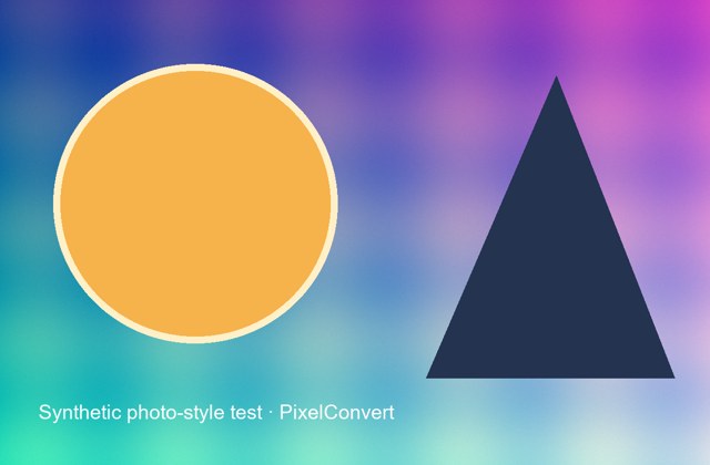
Actual upload-ready output from the synthetic EXIF/GPS source captured on 20 September 2026. Its portrait 420×640 dimensions show that the source orientation was applied to the pixels before the new JPEG was encoded.
- Tagged source
- 640×420 JPEG · orientation 6 + GPS IFD
- Prepared output
- 420×640 JPEG · orientation and GPS omitted
- API result
- 200 · quality 95 · metadata_removed warning
Reproduce the test
These deterministic PixelConvert files contain no personal photos or third-party artwork. Download them to repeat the measurements or test another workflow.
- Download the synthetic tagged source ↓
640×420 JPEG with orientation 6 and non-personal 0° N, 0° E GPS test metadata.
- Download the prepared output ↓
420×640 upright JPEG rebuilt without the source EXIF orientation and GPS IFD.
- Download the measurement record ↓
Captured dimensions, byte sizes, output metadata checks, and logo-conversion results.

Browser and failure checks
- Preparation API
- The request returned 200 with x-image-width=420, x-image-height=640, x-selected-quality=95, x-metadata-removed=true, and x-warning-codes=metadata_removed.
- Source inspection
- The source was reopened before upload to confirm EXIF orientation 6 and a populated GPS IFD were present.
- Output inspection
- The rebuilt JPEG was reopened to confirm it has portrait dimensions, no EXIF orientation value, and no GPS IFD.
How this was tested
scripts/capture_orientation_and_logo_case_studies.py generated a 640×420 derivative of PixelConvert’s deterministic pattern, wrote EXIF orientation 6 and a 0° N, 0° E GPS IFD, then POSTed it to /api/v1/prepare/process with target_format=jpeg and dimension_mode=fit. The script reopened both source and output with Pillow 12.3 to record dimensions and metadata fields.
Read the full PixelConvert methodology →Limitations
- The test proves the current pipeline’s handling of one standard JPEG EXIF orientation and GPS IFD, not every vendor-specific metadata container.
- Metadata removal does not remove private facts visible in the image pixels.
- The synthetic source uses neutral test coordinates and is not a test of a phone camera’s complete EXIF block.
- A recipient platform that re-encodes the file can apply its own orientation handling after delivery, which is outside this pipeline’s control.
Frequently asked questions
- Will PixelConvert make my photo upright everywhere?
- It applies a recorded EXIF orientation to the output pixels. That avoids the common sideways-file problem caused when a recipient ignores the tag. You should still open the result before an important submission.
- Does the prepared file keep my GPS location?
- The preparation pipeline rebuilds JPEG, PNG, and WebP outputs without copying the source EXIF/GPS metadata. The controlled test on this page confirms that behaviour for its tagged JPEG source.
- Does removing metadata make an image anonymous?
- No. Details visible inside the pixels can still identify a place, person, or event. Metadata removal is useful privacy hygiene, not a forensic anonymity guarantee.
- Why does the output have different dimensions from the source?
- Because the rotation was applied to the pixels rather than to a tag. A 640×420 source carrying orientation 6 becomes a 420×640 output. A tool that only deleted the tag would return 640×420 and a permanently sideways image.
- Can stripping metadata make my photo sideways?
- Yes, if the tool deletes the orientation tag without rotating the pixels first. The instruction disappears while the pixel grid stays rotated, so the image renders sideways everywhere. Order of operations is what prevents this.
- Should I delete my original after preparing it?
- No. Keep the original separately if you might need its capture information or highest-quality source. The prepared file is a purpose-built upload copy.
Revision note: Published 20 September 2026 as a controlled orientation-and-metadata test using a public, synthetic source with no personal location data. Reviewed 1 October 2026: added the EXIF orientation value model, why the rotate-then-strip order matters, what a GPS block contains, self-verification steps, and downstream re-encoding behavior. The captured measurements are unchanged.